USEFUL LINKS - UPDATED
FEB 10, 2004
ACAPULCO
IXTAPA &
ZIHUATENEJO
WHALES
http://curry.edschool.virginia.edu/go/whales/home.html
http://dkd.net/whales/
http://www.omplace.com/omsites/discover/index.html
PELICANS
http://www.montereybay.com/creagrus/pelicans.html
http://www.discoverymexico.com/ecology/brown_pelican
WEATHER
http://weather.noaa.gov/fax/marine.shtml
http://www.7knots.com
CABO SAN LUCAS
http://www.allaboutcabo.com/cabocam.htm CABO RESORT CAM!
http://www.allaboutcabo.com/allcslweather.html CABO REAL TIME WEATHER!
PUERTO VALLARTA
http://www.allaboutpuertovallarta.com/ ALL ABOUT PUERTO VALLARTA
PACIFIC COAST OF MEXICO
http://www.tomzap.com/ Map of all the
places we are probably going to go along the Pacific Coast of Mexico
http://www.tomzap.com/map_east.html Pacific Coast of Oaxaca
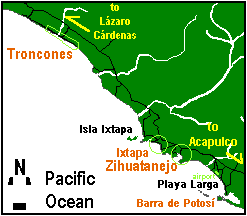
Zihuatanejo's coordinates are 17.633N & 101.550W |
Troncones, La Barra de Potosí, Ixtapa & Zihuatanejo, Mexico
are located in the state of Guerrero fronting the Pacific Ocean about 240
kilometers (144 miles) northwest of Acapulco.
Zihuatanejo is the actual community. Ixtapa is a
government-planned resort area with many high-rise beachfront hotels.
Troncones is a small beach community about 37 kilometers (22 miles) to the
north.
Barra de Potosí, Playa Larga and Playa Blanca form a
15-kilometer stretch of beach to the south of Zihuatanejo, Mexico near the
Aeropuerto Internacional de Zihuatanejo-Ixtapa. |
| The entire region makes up one of the most beautiful beach
resort areas in the world. Diverse, peaceful and secluded. |
|
Enjoy the warmth of Mexico's culture and her people. Bask in
the sunshine on our many tranquil beaches. |
| Come see for yourself what paradise is all
about! |
ACAPULCO INFORMATION FROM WEB
 Click to enlarge map of Acapulco!
GO TO HOME PAGE
